
“Digital cartography & mapping technologies” is one of the thematic areas of the DTU. In the DTU’s proposal to the FNR PRIDE research programme the key terms are outlined as follows: “(…) geographical information systems (GIS) in historical research; best practices in digital cartography; annotation tools; visualisation strategies; geo-referential mapping; animated maps” 1
This thematic area circumscribes a historical research field that has received a major boost over the past two decades, partly as a result of progress in digital humanities. First, ever larger collections of historical maps are being digitised and made available online.2
However, the prerequisite for the use of these technologies is an increasing interdisciplinary openness among historians and a willingness to learn and appropriate techniques, terms and concepts from other disciplines such as geography and computer and information sciences. This has resulted in divergent development, with rapid bursts interspersed with more static periods, and a growing gap in the historical sciences.3
The traditional research on historical town atlases (HTAs) in Europe is a good example to examine this development. We will specifically focus on the first entirely digital and interactive historical town atlas, Luxatlas.lu. This project serves as a “trading zone” in the sense of the DTU and builds a bridge between traditional research and the testing and implementation of “different kinds of methods, approaches, theories and technologies” as defined in the DTU programme.4
The Historic Towns Atlas project
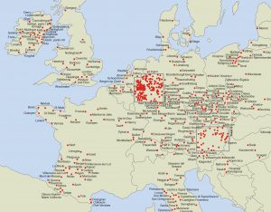
“The European Historic Towns Atlases are a multi-national endeavour for research into the origins and development of European urbanism under the auspices of the ‘Atlas Working Group’ of the International Commission for the History of Towns”5 (ICHT). This European project was launched by the ICHT in 1955. The basic research idea was to use town plans as a means of understanding urban development “by identifying periods of urban growth and to facilitate comparative studies of the topography of pre-modern towns in Europe”.6 The aim was to document the development of towns from the early Middle Ages to present day by “the edition of cartographic and iconographic sources as the basis for the reconstruction of the historical topography of pre-modern urban spaces”.7 The project became a unique success story: with well over 520 published volumes to date,8 the European enterprise of the HTA series “has been the longest-running and most prolific enterprise within the field of urban history and historical geography”.9
Historical Town Atlases and the digital turn
Most of the HTAs published so far are available in printed form, as large-format folders containing folded maps, picture panels and text booklets. As digitisation became more widespread, some national atlas projects were retro-digitised in PDF format and published on the Internet at an early stage. However, the HTA community has not yet adopted a common approach for the adaptation of new technologies and forms of publication such as WebGIS. Different strategies are applied in different countries.
Luxatlas.lu – the project for a digital and interactive HTA of Luxembourg City
The project started at the end of 2016 and is the first to opt for a completely digital and interactive publication, based on open source software, intended solely for online publication on the Internet. At the outset, the key question arose as to how it would be possible to strike a balance between compliance with the rules, regulations and traditions of the ICHT and an innovative form of online publication using WebGIS.10 The development of a coherent concept was only possible through a continuous discussion and improvement process, which made the Luxatlas project a “trading zone”. Ongoing discussions are held on a regular basis with colleagues from the international HTA community, at the annual meetings of the Atlas Working Group at the ICHT, via an HTA Forum and during workshops and conferences, mostly initiated by the Institute for Comparative Urban History in Münster.
A useful exchange between the national and international project partners of Luxatlas also took place at the University of Luxembourg to examine issues related to content, concept, methodology, (digital) source criticism and technical implementation.
The DTU became involved, when the project was presented at the interdisciplinary workshop “Mapping urban history in the digital age”, run by the C2DH in February 2019. Topics raised at workshop were subsequently discussed with doctoral students at the “Spring School Historische Kartographie” in April 2019 at the University of Luxembourg, led by Sonja Kmec and Martin Uhrmacher. In addition, there are regular exchanges with doctoral students specialising in space-related issues, which brings the DTU “trading zone” to life.
Outcomes
This permanent discussion process at several levels has paved the way for the first completely digital and interactive European HTA, which can currently be described as follows:
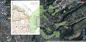
Luxatlas.lu documents historical processes of change diachronically for research purposes, for people interested in history (public history) and for municipal departments (supporting preparations for urban development projects). But the pure visualisation of research results is not the main focus of the project. The town atlas itself serves as an important tool for the acquisition of new knowledge. It is only by means of cartographic representations that comparisons can be made of various historical development processes in Luxembourg City. The superimposition of different cartographic time layers enables users to visualise and analyse specific questions individually. The town atlas therefore offers a basis for further research on urban development. It is only through the cartographic presentation of historical, architectural, economic and urban development information that the distribution of certain spatial phenomena becomes visible and can then be interpreted and analysed. In this way the interactive map becomes a central instrument for acquiring additional knowledge.
With regard to source criticism, it is important to point out that the atlas does not provide any “original” sources, even though the user may not be given this impression. In fact, all the original sources used have been digitally revised and transformed to make them usable for the web atlas. This process and the individual transformation steps are documented transparently on the website (“Quellengrundlage” and “Methodik” on the homepage).11
_
The “Luxatlas” is a particularly successful example of the potential offered by the DTU’s “digital hermeneutics” concept and its role as a “trading zone”: the Luxembourg HTA convincingly documents processes of change diachronically, while also challenging traditional notions of development and establishing new authoritative methods and concepts for the standardisation of online maps.
Edited by Juliane Tatarinov; English Review: Sarah Cooper
Notes
- Andreas Fickers, “FNR PRIDE Application Doctoral Training Unit Research and Training Program: ‘DTU Digital History and Hermeneutics’”, University of Luxembourg (2015)
- See for example the Gallica website, the database of the Deutsche Digitale Bibliothek. Kultur und Wissen online and the Ryhiner map collection.
- See Fickers (2015).
- Ibid.
- “European Historic Towns Atlases”, https://www.uni-muenster.de/Staedtegeschichte/en/portal/staedteatlanten/index.html. For a general description of the HTA project see Howard Clarke and Anngret Simms (eds), Lords and Towns in Medieval Europe. The European Historic Towns Atlas Project. London: Routledge, 2015.
- “Historic Towns Atlases”, extract from a paper by Anngret Simms, https://www.historiaurbium.org/activities/historic-towns-atlases/.
- “European Historic Towns Atlases”, https://www.uni-muenster.de/Staedtegeschichte/en/portal/staedteatlanten/index.html.
- “Distribution map” and “List – European Towns Atlases”, https://www.uni-muenster.de/Staedtegeschichte/en/portal/staedteatlanten/index.html.
- Katalin Szende and Magdolna Szilágyi, Town Typology in the Context of Historic Towns Atlases: a Target or a Tool? In: Political Functions of Urban Spaces and Town Types through the Ages. Making Use of the Historic Towns Atlases in Europe, eds Roman Czaja, Zdzisław Noga, Martin Scheutz, Ferdinand Opll. Cracow – Toruń – Vienna: Böhlau, 2019, p. 267-302, here p. 267.
- Cf. on the concept and the guidelines also https://www.ria.ie/research-projects/irish-historic-towns-atlas/european-project
- On this issue see Andreas Fickers, Update für die Hermeneutik. Geschichtswissenschaft auf dem Weg zur digitalen Forensik?, in: Zeithistorische Forschungen/Studies in Contemporary History, Online-Ausgabe, 17 (2020), H. 1, https://zeithistorische-forschungen.de/1-2020/5823.